Manage government estates more efficiently with data-informed decisions
Utilise Measured Building Survey spatial data to deliver positive outcomes across the lifecycle of an asset, from facilities management and building operations, through to lease optimisation.

0%
REDUCTION IN COST OF MAINTENANCE
Reliable data for common scenarios
Government solutions. USE CASES.
- Faster design, space planning and approval process with BIM-ready 3D Revit® models, enabling collaboration across internal and external teams, and support regulatory compliance
- Optimised equipment installation, including obtaining faster, more accurate estimates and efficient planning for repairs
- Verified schedule of areas reporting, compliant with international and local measurement standards, critical for lease management, including lease administration and accounting
- Use dimensional data and 3D models to document above ground utilities, mechanical, electrical and plumbing (MEP) equipment and furniture, fixtures and equipment (FF&E)
- Replace time-consuming, inaccurate and uninsured manual measurements with guaranteed accurate and compliant Measured Building Survey measurements
- Improve public and employee safety with virtual tours, compliant building plans and interactive 3D models
- Increase situational awareness for employees and first responders in case of an emergency
- Stak delivers fire safety compliant floor plans, that support in planning emergency routes and response strategies
- Train employees and provide superior visibility to first responders in the case of emergency
- DRC’s digital twins enables facilities managers and engineers to determine the most suitable and compliant location of critical equipment
- Easily distribute an accurate 3D model and virtual tour of your facilities with new or visiting employees, so they can quickly understand your space
- Easy to use, intuitive and interactive online platform that all required team members can use
- Educate new employees on complex facilities, especially in hard to reach or potentially dangerous areas, resulting in reduced human error and more consistent operational processes
- Replace time-consuming, inaccurate and uninsured manual measurements with guaranteed accurate and compliant Stak Verified® measurements
- Offer remote, virtual access to historic landmarks and other prominent sites of high-interest
- Improve continuity of operations during adverse weather conditions or other disruptions
- Ensure and expand accessibility to visitors
- Offer remote, virtual access to historic landmarks and other prominent sites of high-interest
- Improve continuity of operations during adverse weather conditions or other disruptions
- Ensure and expand accessibility to visitors
Why it matters
Confidence in compliance
Accurate, RICS-compliant as-built surveys ensure public assets meet regulatory standards and support safe, accountable decision-making.
Better planning for public services
Verified spatial data helps teams optimise layouts, allocate resources, and plan refurbishments or upgrades across public buildings and civic infrastructure.
Clear insight for long-term stewardship
Reliable digital deliverables give governments and public agencies the clarity they need to manage assets, improve accessibility, delivering better outcomes for communities.
The trusted surveying partner for Government and Public Spaces
COMPLAINT. guaranteed. verified.
We're a global team of industry leading specialists in surveying, architecture, technology and International Property Measurement Standards.

We have digitised over
150,000 buildings
350 million sqft
350 million sqft
Real estate under digital management
$500+ billion
View an example project
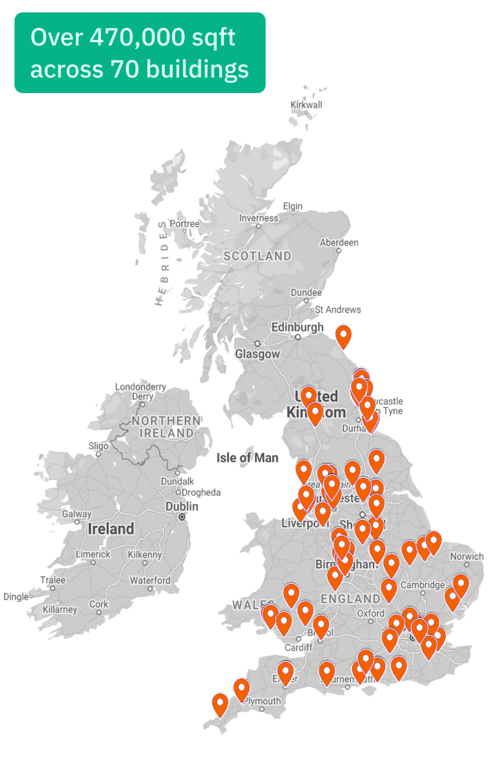
Ministry of Justice, UK
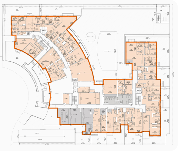
The Ministry of Justice (MoJ) entrusted DRC with digitising a part of their real estate portfolio, comprising 70 buildings across the UK and over 470,000 square feet. We successfully captured every building in just 35 days.
DELIVERED FOR THE MINISTRY OF JUSTICE, UK


REQUIREMENTS AND DELIVERABLES.
- Our ability to work at such a rapid pace and coordinate all project management and logistics without compromising on quality was a key differentiator for the Ministry of Justice, who required reliable data to support their operations
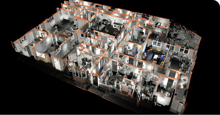
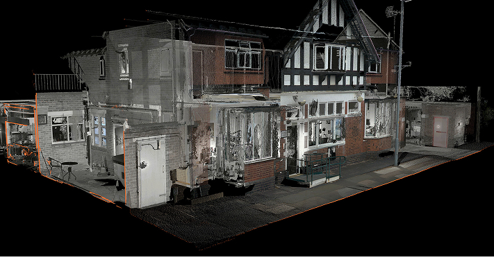
- Measured Building Survey verified floor plans, including schedule of areas, professional photography and digital brochure page
- Scan-to-CAD with client specific inclusions
- Location: 70 buildings across the UK
- Area: Over 470,000 sqft
- Asset class: Commercial
- Purpose: Procurement of FM contract
Speak to our team for further details
Explore the services we provide
Verified. ACCURATE. EFFICIENT.
With rich, accurate 3D datasets and ground breaking end-to-end technology, DRC delivers a wide-range of industry leading assets.
Measured Building Survey
Delivering accuracy you can trust, we create a single verified dataset that helps you understand and showcase your property with confidence.
Scan-to-CAD
We transform 3D scans into detailed 2D CAD drawings, delivering accurate floor plans, sections, and elevations derived from verified point cloud data.
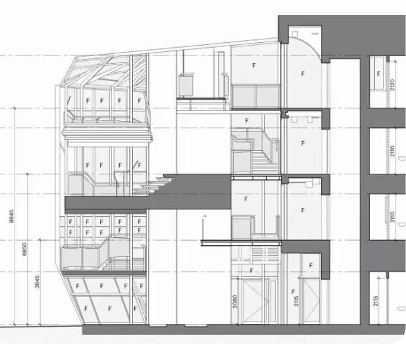
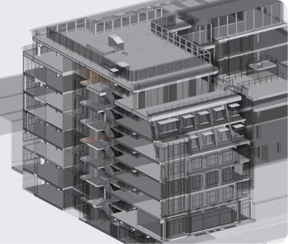
Scan-to-BIM
Using advanced laser scanning and BIM technology, we create high-accuracy 3D models with full architectural, structural, and MEP detail.
UAE Surveying Services
We are an approved third-party surveyor, specialising in off-plan (Oqood, as-planned) and completion (title deed, as-built) surveys.

TEST