Reduce risk and accelerate development with
complete spatial clarity
Developers face tight timelines, complex sites, and costly design uncertainties. Verified as-built data helps teams make faster, more informed decisions, reducing redesigns, avoiding on-site surprises, and improving coordination across every stage of a development project.

0%
reduction in cost compared
to traditional surveys
to traditional surveys
Real value for all
stakeholders
ROI AND BENEFITS.
Whether you're assessing feasibility or tracking on-site progress, we give your team accurate, reliable spatial data, so you can make design decisions, monitor construction, and submit documentation without delay.
- Development and fit-out drawings
- Asset quantification
- MEP and structure documentation
- Design opportunity assessments
- Wayleave and rights tagging
- On-site audits and milestone recording
USING OUR MEASURED BUILDING SURVEY
- Assess feasibility quickly with verified dimensions and accurate spatial layouts
- Reduce design iterations by giving consultants a reliable as-built baseline
- Identify structural constraints early to avoid rework and planning delays
- Accelerate consultant onboarding with clear, reliable as-built information that eliminates early-stage uncertainty
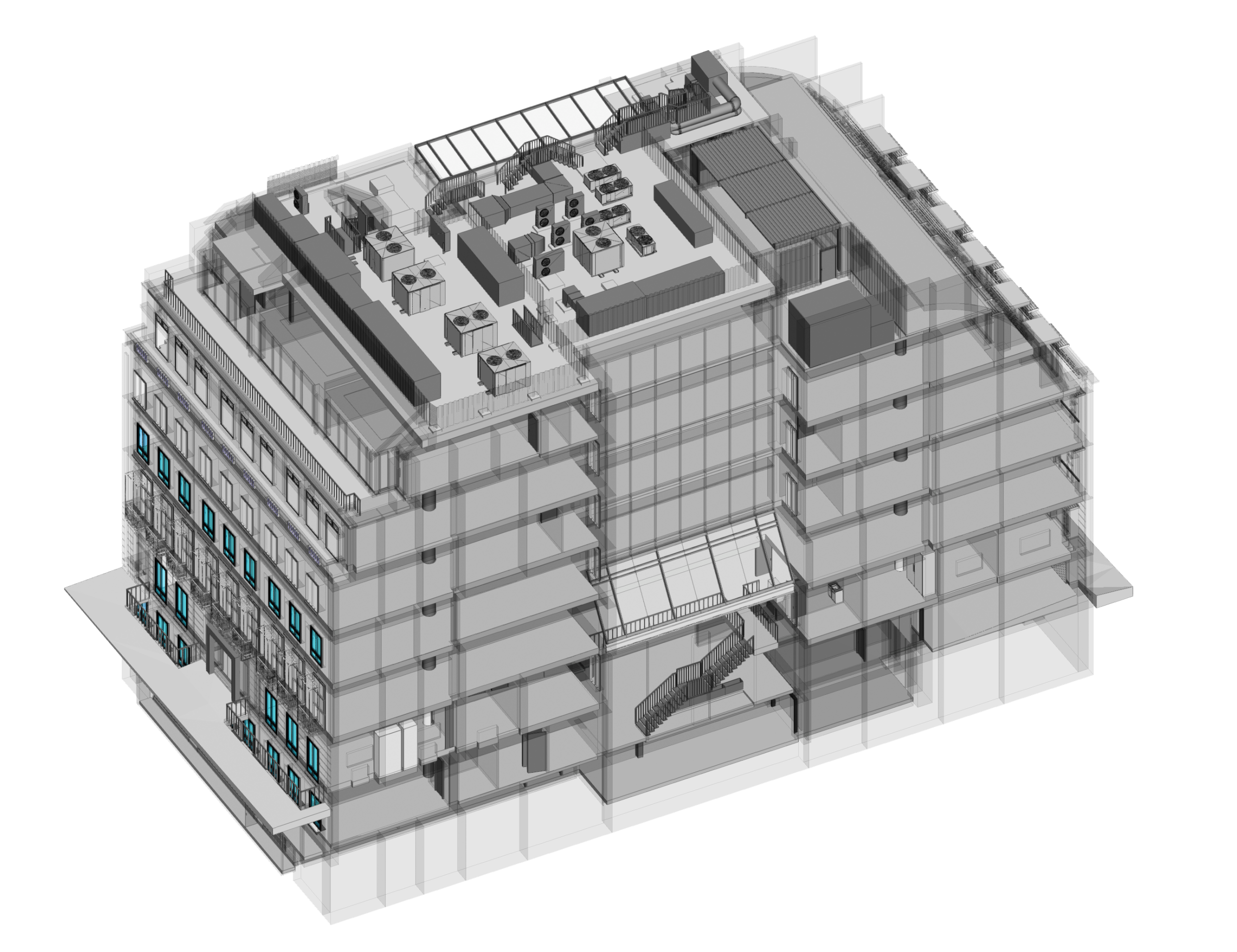
USING SCAN-TO-BIM
- Get ready-to-use CAD files that accelerate early-stage design and concept development
- Streamline coordination with architects, engineers and planners using a single, trusted dataset
- Reduce time spent redrawing as-builts manually, eliminating transcription errors
- Enable faster site analysis, test fits, option studies, and redevelopment planning
USING SCAN-TO-BIM
- Provide design teams with BIM-ready models for more accurate early modelling
- Support clash-free design development with reliable existing-conditions geometry
- Improve coordination between disciplines by working from a unified as-built model
- Establish a digital foundation that supports long-term asset planning and FM integration

PROFESSIONAL PHOTOGRAPHY

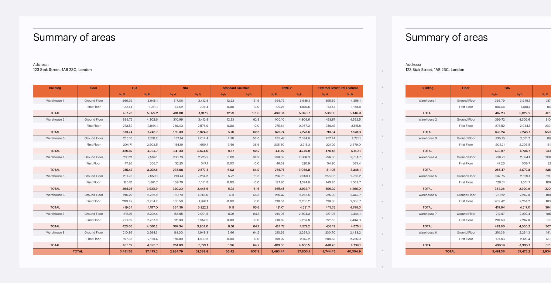
Verified area measurement reports
Need a quote for your building or portfolio?
See how we can support you, explore Stak Hub today.
explore stak hub
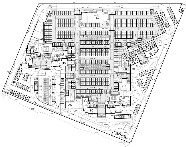
scan-to-cad
SCAN-TO-BIM
360° Virtual tour
Why it matters
Clarity from
day one
Verified as-built data gives developers a reliable foundation for feasibility studies, early design work, and confident decision-making
Fewer delays and costly
surprises
Accurate spatial insight reduces redesigns, eliminates measurement errors, and helps teams anticipate constraints before they become problems.
Smarter, faster
planning
Unified CAD and BIM deliverables streamline consultant coordination, accelerate approvals, and keep projects moving with greater certainty.
Stak Hub, our easy to use
online client platform
Explore and manage your
spatial data effortlessly.
spatial data effortlessly.
- Access verified and insured spatial data of your buildings
- Secured central hub for all your buildings
- Online access to enable realtime decisions from anywhere in the world
- Can be organised on a portfolio level
- User access control within your organisation
- Private links to assets for exclusive access
We deliver verified, accurate as-built data
you can trust. With a single capture, you
receive complete digital records that
reduce risk, accelerate feasibility, and
give your development team a clear foundation for every decision.
you can trust. With a single capture, you
receive complete digital records that
reduce risk, accelerate feasibility, and
give your development team a clear foundation for every decision.
We've digitised 180,000+ spaces, totaling
390+ million square feet